 |
|
|
Project Leaders:
|
Researchers:
Research Area:
|
Information: |
||||||||||||
Research
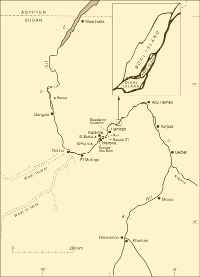
Program A new high dam is under construction in the Nile’s Fourth Cataract zone, northern Sudan. As early as 2008 a reservoir 170 km in length and up to 4 km wide will flood the barely known stretch of the Nile valley between Hamdab and Abu Hamed. The project is part of an international rescue campaign initiated by Sudan’s National Corporation for Antiquities and Museums (NCAM). It aims at reconstructing the environmental potential and the Holocene history of actual human use of a specific part of that region: Boni Island (50 km²), being the largest of the many islands liable to at least partial flooding. Within the river oasis surrounded by desert the cataract situation makes for very special conditions for human existence, especially for agrarian societies practising irrigation horticulture. Arable land is restricted to an extremely narrow zone next to the river, on average not even 50 m wide. On the other hand, after the yearly high flood numerous temporary water courses and islands on falling dry offer seluka land, apt for cultivation on naturally moist soils. The intensive system of todays Manasir population allows three annual harvests. Due to the time pressure given the archaeological investigations 2005–2007
will focus on systematic intensive foot surveys covering the whole island
and the adjoining right bank of the Nile. The goals include: (1) A complete
documentation of sites from all periods, their mapping, dating, and
interpretation. Limited test excavations of selected sites and features
will be carried
out in order to check on the fieldwalking results, to gain additional
information, and to provide samples for archaeobotany, zooarchaeology,
palaeogeography and scientific dating. The aim is to derive diachronic
patterns and processes of settlement and land use to be compared with
the recent irrigation system. The field data will also be analysed with
respect to demographic developments and modes of subsistence against
the background of varying climatic and ecological conditions. (2) Alongside
it is intended to build up from the literature a database of similar
situations in the area between the First and the Fourth Cataracts. (3)
Pertinent Egyptian and Napatan texts will be systematically analysed
for ancient conceptions of cataract regions. The approach is designed
to allow (4) a structural comparison between the Fourth Cataract and
its counterparts in Middle and Lower Nubia. This will add a new type
of landscape, not so far investigated under the umbrella of ACACIA, (5)
opening up avenues of comparison with other landscapes in arid Africa.
A pilot survey season early in 2004 yielded archaeological sites, features,
and finds from the Middle Palaeolithic to medieval and modern times.
From the more recent of these periods there is an abundance of burials,
cemeteries, settlements, and rock art sites. One of the questions to
be asked of that material is whether the cataracts really acted as cultural
and territorial divisions between the Nile’s reaches, as is conventionally
assumed, or rather linked them up with one another by virtue of their
specially rich natural potential. As for the Fourth Cataract it will
also be important to try to illuminate its temporary significance as
a border zone between the Egyptian and Nubian states. |
 Research Area |
| [Main]
[Project A1] [Project
A2] [Project A3] [Project
A5] [Project A6] [Project
A7] [Project
A8] [Project
A9]
[Project
A10] |