|
|
|
|
Project Leader:
|
Researchers:
Research Area:
|
Information: |
||||||||||||
Research Program: Introduction
In northeastern Africa the culture of Ancient Egypt (ca. 3.200BC - 400AD) holds an exceptional position because of the abundance and the variety of its textual and pictorial sources. Cultures offering equivalent corpora of informations are neither found in the areas west of Egypt (Libya) nor in the southern regions of Ethiopia and the Sudan (Nubia). In project SFB.389/A.5 there are two principal objectives:
With the Old Kingdom (ca. 2.700-2.200BC) there is a chronological focus of work because only the sources of this epoch give the possibility to draw directly a connection between the fields of A.5 and the other archaeological projects A1-A2.
|
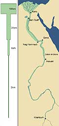
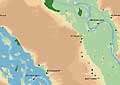
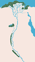
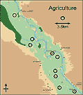
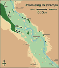
Landscape In topographical terms Ancient Egypt is the land of the Nile Valley from the cataract-region near Assuan in the South to the Mediterranean Sea in the North. Considering the deserts spreading out on both sides of the river the people of Ancient Egypt don´t believe that these seemingly borderless regions being quite different from the river-landscape are parts of their home-land. So relating to its position and inner structure Ancient Egypt differs deeply from other regions in Northafrica. The position is the northeastern edge of the continent and because of that the land becomes an inner part of the enormous arid zone, which covers Africa in its northern half - and that in a time long before the rise of the culture at 3.000B.C. The inner structure of Ancient Egypt is that of a gigantic river-oasis. The inundation-mechanism of the Nile becomes its hydraulic base. Rain plays no role in any cultural or economic development. Today it seems to be a fact that the rising of Ancient Egypt round about 3.000B.C. takes place in a time, in which the process of desiccation reaches new heights and the hyperaridity and the desertification are deeply established again in northeastern Africa. It is another side of this fact that the culture does not grow in earlier times, especially in the "wetphase-situation" between 9.000B.C. and 5.000B.C., in which the climate is wetter and the environmental situation seems to be much better for cultural developments than 2.000 years later, when Egypt actually will be born. The long way of the Nile from the headwaters in Ethiopia and Uganda to the Mediterranean Sea shows a pattern of sections influencing the nature of the river-landscape in its parts (Picture 1). The breadth of the Nile-valley on the "cataract-stage" from Khartoum to the Gebel el-Silsile is on an average less than 6km. Between the Gebel el-Silsile and the end of the characteristic Nile-turn at Qena the breadth is approximately 6 km. Then it adds to 20km between Nag Hammadi and Beni Suëf in the line of the Faijum. In the Nile-Delta the situation differs extremely and here the areas reached by the Nile-floods have a length of 100km and more. There is another effect of that "step-by-step"-extension of the valley. Going north the number of the Nile-branches increases. In a historical view this situation is very difficult to describe, because every branch - as the main branch itself - is not an unchangable, stable factor, but a dynamic, moving element in the valley-landscape. The high-dams, which are built since the 19th century, brings difficulties to recognise the exact historical situation too. Nevertheless the fact of the increasing number of Nile-branches is sure, and at last in the Delta north of Cairo there are over the time two, five and seven different rivers, which transport the waters of the Nile to the mouths at the Mediterranean Sea. Going north this kind of "river-multiplication" being connected with the expansion of the valley strongly leads to a reduction of the velocity of waterflow. So the development of the river-landscape have deep influences not only upon the quantities of grounds but also upon the qualities of their soil. In Nubia and the southern parts of Ancient Egypt there are relatively small areas within the valley of the Nile which can be used for settlement, agriculture, cattle-keeping etc. (Picture 2). The nature of the landscape may be one of the main reasons why the "country of the Nubians", the later first nome of Upper Egypt, does not become a part of the political state in the time of dynasties 0-5 (3200-2400B.C.). Coming down to Thebes in Upper Egypt, then going northwards over Assiut, Akhmim and Bani Suëf and at last reaching the Delta the areas being reached by the floods in ancient times highly increase and the qualities of their soil are much better than in the southern regions (Picture 3). It´s not without any risk to describe the structure of the landscape of Ancient Egypt within the scope of a few terms, but simplifying it in such a way we get the possibility to compare the landscape with the culture occupying it and looking at different aspects as terminology, pictorial evidence, economic system, religious believe etc. we are able to draw some conclusions from the correspondences we recognize. Ancient Egypt is the river-oasis of northeastern Africa. Principally
speaking its structure consists of five factors: (i) the river itself,
(ii) natural high-dams and gazîras, (iii) alluvial grounds, (iv)
marshes and swamps, and at last (v) the desert-regions outside the valley
strictly fixing the borders of the land (Picture
4). Another description of this very schematic kind of landscape-structure
written in German can be found under: The key of the environmental development is the river "Nile" itself with its characteristic flooding activities. The water supply of the land and its culture is completely based upon the river and its inundation mechanism. In ancient times the annual Nile-flood begins in the middle of July and marks the beginning of the Egyptian calendar-year with its three seasons "inundation", "emergence" (of the alluvial grounds from the water) and "deficiency" (of water). Regularly the inundation reaches its peak in the first days of September; on the other side the "low-phase" is between the middle of May and June. There are three fundamental functions of the Nile:
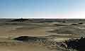
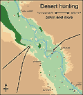
Directly on the banks of the branches often are located natural dams. And in some distance of them in the area between the river and the deserts there is another kind of the same landscape factor: the so-called gazîras, arabic for "islands". Dams and gazîras are higher grounds and normally not reached by the seasonal inundations of the Nile. So being "non-flooded" these high-grounds inside the valley are dry and safe places and because of that the most attractive regions for founding villages and towns consisting of streets, places, huts and houses, stables and enclosures for animals etc. Although the historical development is too complicated for describing it within the scope of a few sentences we can recognise a principal shift of valley-colonization from prehistoric to historic times. In prehistoric times for the most part settlements occupy the areas at the edges between the valley and the deserts. These situation changes in historic times. Now the Egyptians more and more found their villages and towns inside the valley bringing them directly in the neighbourhood of the water-streets and the alluvial-grounds which are used for agriculture. This shifting from desert to valley is more a long process continuing some centuries than a short event being limited to one or two years. Large areas of the Egyptian Nile Valley consist of alluvial grounds which in historic times are flooded seasonally for 3-4 months (Picture 5). These areas are used mainly for agriculture, which - as the inundation itself - deeply determines the economic system of Ancient Egypt through the different epochs of its history until 400A.D. Sowing takes place after the decline of the inundation; harvest follows around four to five months later before the beginning of the Egyptian summer, the time of the "deficiency of water". The seasonally flooded grounds have two characteristics, which are important for the economic and so for the cultural development since 3000B.C. First gazîras and border-dams on the one side bearing the settlements and the alluvia on the other side being important working-fields are located to each other without great distances. The ways between the fields and the villages with their threshing-floors, storages, stables etc. are relatively short and so the transports easy to handle. Secondly the alluvial grounds offer a gigantic potential of an economic resource, which Ancient Egypt is not able to realize directly at the beginning around 3.200-3.000B.C., but "step-by-step" in its long history. At the beginning of the Old Kingdom around 2.700B.C. in Egypt only there are four extensive regions, which have the distinctive features of marshes or swamps. It is possible to locate them in the Fajum; at two points in Middle Egypt on the western border of the valley near el-Minia and Assiut respectively and at last the huge marshes in northern Lower Egypt, which separate the whole country from the Mediterranean Sea (Picture 6). In the swamps ground water comes to light, water level is low and there is almost no velocity of water-flow, so that the temperature of water becomes relatively high over the time - important conditions for the rich vegetation of plants as reed, papyrus and Lotus. Although the extensions of the swamps are rather different from the alluvia Ancient Egypt is able to use their resources and to give them an important role in the economic system of the state. For example the north marshes in Lower Egypt can be located as a centre of fishing, bird-catching, cattle-keeping and different kinds of using plant-materials, especially papyrus. Over the whole time of its history Egypt is part of the huge desert regions of Northeastern Africa. The Nile Valley has a quite different character and of course the ancient Egyptians never have the feeling that the deserts are parts of their home (Picture 7). On the other hand they are very interested in these regions which seem to be so unattractive for everybody who have only a smattering knowledge (project E.3). Today it seems not impossible that a few roots of the culture lie in the deserts outside the valley, especially in the seemingly borderless regions of the Western desert between the Nile Valley and the Gilf Kebir (projects A.1-A.2). And this may be the reason why hunting desert animals is not only known in Ancient Egypt, but is together with agriculture and swamp-activities one of the important pillars of the economic building of the state in the Old and Middle Kingdoms down to 1.800B.C.
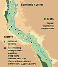
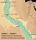
Economy The position of settlements and cemeteries clearly demonstrates their economic background, because they strictly take into consideration the narrowness of the fertile and attractive regions. In historical times villages and towns mainly are founded on the gazîras and natural dams within the valley. The cemeteries belonging to are lying in the border-regions outside, which from a productive point of view are completely un-productive (Picture 9). In this very characteristic position they don´t block the relatively small areas of gazîras and dams bearing the houses, storages, stables, gardens etc. and additionally they are in the shortest distance from settlement as possible. This relation indicates that beside the settlements the cemeteries are a component of the system too. For the most part we get our information about the economy of the Old and Middle Kingdoms from the wall-decorations of the tombs of kings and nobles. Here in detail the "workaday-life" is described and so there are large picture-cycles dealing with the different producing sectors in a way "step-by-step". For characterizing them as part of the system we have to find two distinctive features: (1) first an overlying administration and (2) secondly a complex structure of organisation. The first indicators for a supra-regional administration are the different scene-types of registration, by which every producing-cycle is concluded. Simplifying the situation we can say that there is no producing without registration of the results - and this leads to an administrative profession of its own. Another strong indicator is the scene-type of the so-called "domains" strongly being connected with the different producing-cycles. Domains are figures of women or men bearing some articles and being equipped with the name of the village having produced them. Typically domains are placed in rows often consisting of 10 figures and more and so they represent productive associations. A high-developed structure of organisation is a clear sign for an economic system. The degree of its complexity can be recognised in the logistics, that means in the ways of transportation of goods and products over long distances. Looking at the three main economic sectors of the Old and Middle Kingdoms, i.e. hunting, working in swamps and marshes and at last agriculture, there can be recognised, that the actual producing activities are carefully embedded between the different processes of transportation and subsequent treatment. In agriculture large droves of donkeys are used to bring the grain from the fields in the alluvial grounds over 3-5km to the threshing-floors in the villages (Picture 10). In the great camps at the borders of the swamps the gathered plants, fishes and birds are collected and prepared. Then it is necessary to construct boats and rafts for transporting the products over round about 20km to the next settlements (Picture 11). At last from a modern point of view it may be a logistic high-light that hunters bring animals as antelopes and gazelles alive from the hunting-grounds deep in the deserts to the villages in the Nile valley and so manage distances of 50km and more (Picture 12). |
(click to enlarge) Picture
1
Picture
2
Picture
3
Picture
4
Picture 5
Picture 6
Picture 7
Picture 8
Picture 9
Picture 10
Picture 11
Picture 12 |
Working on this project is still in progress. Updates will follow on a time to time basis.
| [Main]
[Project A1] [Project
A2] [Project A3] [Project A5]
[Project A6] [Project
A7] [Project
A8] [Project
A9] [Project
A10] |