|
|
|
|
Project Leaders:
|
Researchers:
Research Area:
|
Information:
|
||||||||||||
|
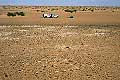
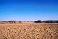
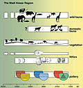
Research Program and Current Activities Located at the southern fringes of the Libyan Desert, Wadi Howar is the largest dry river system in the presently hyper-arid and uninhabitable Eastern Sahara, stretching over 1,100 km from its source area in eastern Chad to the Nile. Geoscientific investigations have shown that during the early Holocene this wadi was the Nile's most important tributary from the Sahara. Later, it became a chain of freshwater lakes and marshes supported by local rainfall, until it ultimately became extinct about 2,000 years ago. A once ecologically favoured area of settlement and communication route between the inner regions of Africa and the Nile valley, Wadi Howar bears abundant prehistoric sites providing evidence of important population movements and interregional cultural contacts. Archaeological, archaeozoological, archaeobotanical and geoscientific research in this still widely unexplored area focus on varying settlement patterns, and survival and subsistence strategies which were adopted by the human groups in order to cope with the dramatic climatic and environmental changes as well as the large-scale role of the Wadi Howar as a turntable between the Sahara, the Nile valley and the more southerly regions. During several field campaigns between 1995 and 2006 in the Wadi Howar and the adjacent areas (see pictures and map), about 2400 archaeological sites have been discovered, providing evidence for human settlement between the 6th and 2nd millennia BCE (see figure). Among the excavated material, pottery - the first synthetic material in the history of mankind - proved to be the most important source of information. Different pottery phases can be distinguished reflecting the settlement history of the region. Well-preserved faunal remains allow to reconstruct the subsistence pattern of each phase. Mapping and detailed stratigraphical analysis of the geological deposits provide information on the current environmental and climatic conditions framing the prehistoric settlements. The first traces of human settlement are represented by ceramics decorated with Dotted Wavy Line and Laqiya-type patterns, which date to the 6th and 5th millennia BCE. The prehistoric groups practised fishing, hunting and gathering. During the 4th millennium BCE a new mode of subsistence appeared: intensive cattle herding (Cattle in the Wadi Howar Region). Leiterband- and Halbmondleiterband patterns are typical for the decoration of the ceramics of this period. In Lower Wadi Howar, incised herringbone patterns appear. With the onset of the Handessi Horizon at around 2200 BC, that is characterised by geometric patterns, a further change in the way of subsistence occurred. This time it was an obvious response towards increasing aridity: small livestock, sheep and goat, were added to the herds. The varying intensity of prehistoric human activities in the different areas of the Wadi Howar region can clearly be attributed to environmental changes: At the beginning of the Holocene settlement, all sectors but the Middle Wadi Howar which was too wet and marshy, were intensively used. With the Leiterband Horizon, the focus of prehistoric settlement shifted to the Middle Wadi Howar. During the Handessi Horizon the Ennedi Erg region and Lower Wadi Howar were no longer suited for permanent settlement due to increasing aridity. Lower Wadi Howar was, however, still used as an important thoroughfare. Beyond the research activities, ACACIA's long-term commitment to protect the natural and cultural heritage of northern Sudan that included a joint mission with Sudanese experts in 1998 which for the first time surveyed the entire length of Wadi Howar, has resulted in the official declaration of more than 100,000 km² as „Wadi Howar National Park“ (Wadi Howar National Park) in 2001.
Perspectives During the final years of ACACIA - Project A2, research will concentrate on the refinement of the chronological framework of environmental, climatic and cultural change in the southeastern Sahara and its economic and social implications, focusing on the role of Lower Wadi Howar where most archaeological field work during the past three years was done. Here, different spheres of influence are visible via different pottery design styles for the 4th and 3rd millennia BCE: Leiterband patterns point to cultural contacts with western areas such as Middle Wadi Howar and the Ennedi Mountains, the various incised herringbone patterns indicate contacts to the Nubian Nile Valley. The analysis of the anthropological material excavated is part of the PhD-project of Erik Becker. |
(click to enlarge)
|
| [Main]
[Project A1] [Project A2] [Project
A3] [Project A5] [Project
A6] [Project A7] [Project
A8] [Project
A9] [Project
A10] |